It looks set to be one of the most settled Christmas periods we’ve had for several years, with high pressure dominating the weather.
The downside, of course, is a lack of snow on Christmas Day — but I suspect most of us would happily take quiet conditions over more wind, rain and a possibility of snow.
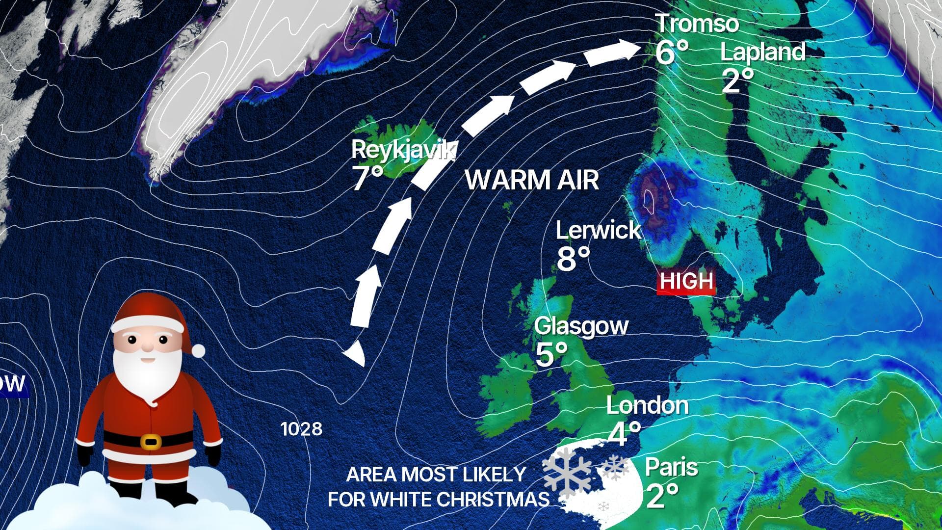
What’s particularly interesting about this high-pressure system is its position. Around Christmas, it’s pushing warmer air northwards into the Arctic, while colder air is being dragged south into Europe.
That means Shetland will actually be closer to the milder air, with highs around 8C on Christmas Day.
 STV News
Meanwhile, cities such as Glasgow, London, Paris and even Madrid are likely to see temperatures around 5C.
Even more unusual is the outlook for Tromso, well inside the Arctic Circle in northern Norway.
On Christmas Day it may reach around 8C with rain — when temperatures there are usually below freezing with snow at this time of year. So it’s fair to say the festive weather is a bit topsy-turvy.
And what about a white Christmas?
Well, the topsy-turvy theme continues. The parts of the UK with the highest chance of seeing snow on Christmas Day are actually Cornwall, Devon, Wiltshire and Hampshire in the south of England, with some models even hinting at a risk of heavy snow for a time.
Closer to home, the best we’re likely to manage is the odd flurry over the eastern Grampians or the Southern Uplands — and even that is far from guaranteed.
For most of us it’ll be a dry day with a little sunshine.
Beyond Christmas, the largely dry and settled weather looks set to continue, though it will turn chillier. Frost and fog will become more of a feature, which should at least make it feel more traditionally Christmassy.
There are some early signs that the pattern could break around the turn of the year, with a colder northerly airflow a possibility.
That could bring an increased risk of snow to northern and eastern parts of the country — but it’s a long way off and likely to change.
The good news is that, for now, we’re heading into a quiet spell through Christmas and New Year, which should also mean New Year street parties are unlikely to be disrupted by the weather this year.
Follow STV News on WhatsApp
Scan the QR code on your mobile device for all the latest news from around the country