Parts of Scotland are to be battered with a deluge of heavy rain as the Met Office issues a yellow weather warning.
Persistent and heavy rain is expected on Tuesday, potentially leading to difficult driving conditions due to flooding on roads.
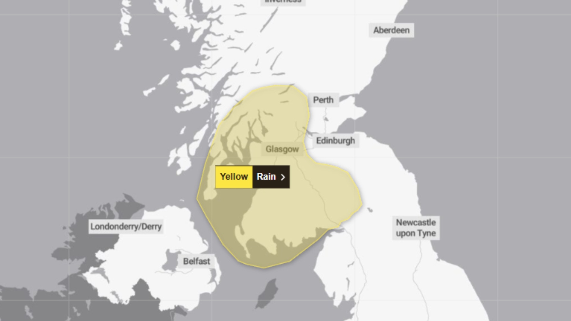
Drivers are being urged to expect spray and flooding on roads, with the warning in effect between 10am and midnight on Tuesday.
There is a risk of disruption to rail, air and ferry routes, with journey times extended.
The most persistent and heaviest rain is most likely, but not exclusively, to be on south-facing high ground, particularly for Dumfries and Galloway.
Between 20 to 40mm of rain is likely to fall quite widely, with a few places perhaps seeing in excess of 60 mm by the end of the day.
Accompanying the rain, winds are expected to strengthen along exposed Irish Sea coastlines, with gusts to gale force possible.
The following areas are covered by the alert:
- Clackmannanshire
- Falkirk
- Perth and Kinross
- Stirling
- Dumfries and Galloway
- Scottish Borders
- West Lothian
- Argyll and Bute
- East Ayrshire
 Met Office
- East Dunbartonshire
- East Renfrewshire
- Glasgow
- Inverclyde
- North Ayrshire
- North Lanarkshire
- Renfrewshire
- South Ayrshire
- South Lanarkshire
- West Dunbartonshire

Insight Sean Batty STV News Meteorologist
With weather fronts expected to become slow-moving across Scotland on Tuesday, some areas could see significant rainfall accumulations – with the main focus on southern and western parts of the country.
The heaviest rain is likely around the hills of Galloway, where as much as 60mm could fall through Tuesday – roughly a week’s worth of rain in one day. Elsewhere, 30-40mm is expected quite widely across Dumfries and Galloway, Ayrshire, Renfrewshire, Dunbartonshire, Glasgow, and parts of Argyll and Bute.
While this is fairly typical for a spell of wet autumn weather, the sheer volume of rain over such a short period, combined with drains blocked by fallen leaves, could lead to localised flooding on roads. Drivers should take extra care on rural routes, where surface water can spread across entire roads, increasing the risk of aquaplaning and loss of control.
Some further rain is expected on Thursday, but beyond that, conditions should turn much drier as we move towards a colder spell next week.
Follow STV News on WhatsApp
Scan the QR code on your mobile device for all the latest news from around the country