Key Points
-
 Yellow warning extended from noon on Friday until Saturday afternoon
 - All but three areas in Scotland to be hit with snow and ice
- 30cm of snowfall possible in higher areas in Scotland
- Hundreds of schools remain closed on Friday in the north
- Disruption expected on roads, rail, air and ferry routes throughout weekend
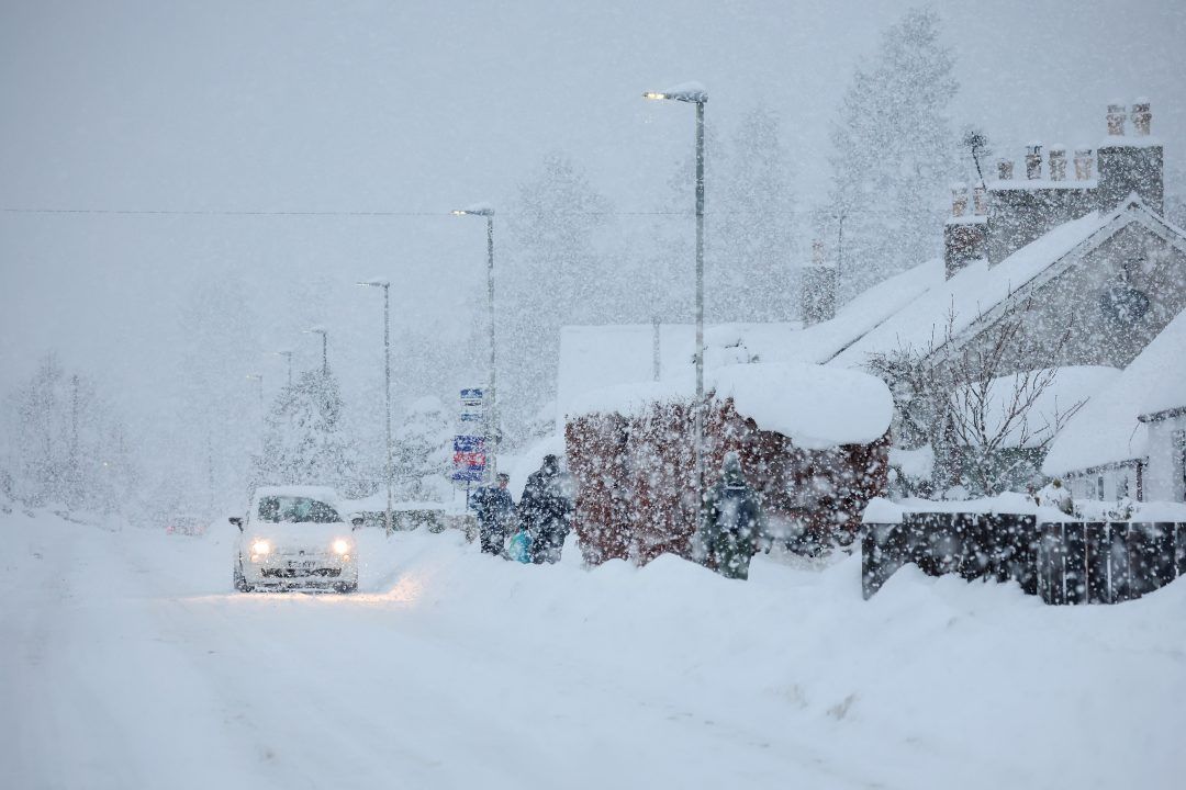
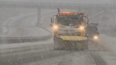
Scotland is set to be hit with more heavy snow and icy conditions over the weekend after days of disruption across the country.
The Met Office has issued a yellow alert for snow and ice on Saturday and Sunday, extending an initial alert which was due to end at noon on Friday.
The new warning now covers almost all of the country until 3pm on Saturday. Then another alert for snow and ice comes into force around 2am on Sunday until 3pm.
As much as 10cm of snow could fall locally, while higher areas could see as much as 30cm of snowfall.
Only Orkney, Shetland and Comhairle nan Eilean Siar are not covered by the warning on Saturday, with Orkney covered for Sunday’s warning.

The latest alert comes after days of disruption due to heavy snowfall, particularly in the north east of Scotland where schools have been unable to reopen following the Christmas break.
Hundreds of schools were closed across regions such as Aberdeenshire, Moray, Orkney and Shetland for multiple days due to heavy snow and ice.
Several Met Office warnings, including an amber alert for snow and ice, have been issued over the last week, bringing a snowy start to the New Year.
The latest weather alert has warned of disruption on roads, vehicles and passengers being stranded, and cancellations to rail and air travel.
There is also a chance of injuries from slips and falls on icy surfaces, and power cuts may occur.
On Sunday, 2 to 5cm of snowfall is likely, possibly locally up to 10cm. Above 200 metres, 10 to 20cm is possible, and potentially 30cm on hills exposed to the strong southerly winds over the highest parts of Scotland.
Strong winds will lead to some drifting of the snow, and widely icy conditions are likely.
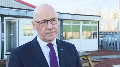
Remain vigilant, warns First Minister
On Friday, the First Minister visited the north east which has been battered by heavy snowfall in the last week.
Speaking to STV News, John Swinney said: “There’s a bit of respite today, but we are looking with some anxiety at the weather information over the weekend. We don’t have absolute clarity from the Met Office about the likely conditions, but I would encourage members of the public to remain vigilant about the weather warnings.
“It’s very clear that we’ve been dealing with a very significant weather incident so far this year, and there is every likelihood that that may carry on over the weekend.
“We will be intensely focused on making sure that all of the preparations that can be made are made, and that the support is in place to assist individuals to make sure that the impacts are minimised.”
‘One of the worst winters in years’
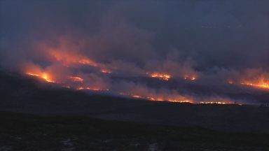
The latest weather alert comes after several days of extreme weather, with 440 schools forced to close on Wednesday across a number of council areas, amounting to 18% of the entire school estate.
Meanwhile Aberdeenshire Council declared a “major incident” on Tuesday due to the heavy snow.
The village of Insch in Aberdeenshire was cut off after nearly a foot of snow fell in the area, with locals describing it as “one of the worst winters in 25 years”.

Insight Sean Batty STV News Meteorologist
All the main weather headlines and your social media timelines in the next few days will be full of Storm Goretti, which is set to bring heavy snow in places, torrential rain, and strong winds. But that’s in England and Wales.
For us in Scotland, this system robs some of the energy from the snowfall we’ve seen recently, particularly across the north east. That said, wintry weather isn’t done with us just yet — sleet and snow showers are expected to return to eastern parts of the country on Friday and Saturday, this time also affecting areas such as Fife, Edinburgh and the Borders too.
If you’re already fed up with the cold, brace yourself – for some places it’s about to get even colder. Overnight temperatures could fall below -15C in parts of the Highlands, west Aberdeenshire and Perthshire over the coming nights, with Friday night likely to be the coldest.
A few computer models have even flirted with -20C, which would be extremely rare and very much at the lowest end of what’s possible. While that’s unlikely to be officially recorded by Met Office stations, it gives a sense of just how cold the air mass currently is.
Now, if – like me – you’ve had no running water for days thanks to frozen pipes and you’re desperately waiting for a thaw, there is hope. By Sunday and Monday, a southerly airflow should begin to spread across the country, nudging temperatures upward. However, during this transition there’s a risk of another spell of snow, particularly across northern and eastern areas – probably the last thing many of you want.
This should be temporary though, as the milder air gradually wins out early next week. Before you get too excited, “milder” might be stretching it – “less cold” is perhaps a better description. Afternoon highs should reach around 4–6C, though overnight frosts will still be possible. It’s an improvement on what we’ve endured this week, but still on the chilly side.
Now for the twist – and potentially the next story. Looking further ahead, there are signs the polar vortex could slow down again later this month. That increases the chance of blocking weather patterns developing, which could allow the cold air to return – possibly from the east this time.
At this stage it’s very uncertain, with only a handful of models hinting at this scenario, but if it does materialise it could bring another spell of very cold weather towards the end of the month and into February.
One possible outcome would be a large area of high pressure setting up over Scandinavia – something we don’t see all that often these days, but when it happens it can drag bitterly cold air out of Russia and into Europe, and sometimes reaches as far as the UK. A similar setup was responsible for the Beast from the East in 2018 – although that arrived in early spring, limiting its overall impact compared to what it could do in mid-winter.
If you’re hoping for a dramatic warm-up, fully thawed pipes, and ice-free pavements, you may need a bit more patience. Stay warm out there.
Follow STV News on WhatsApp
Scan the QR code on your mobile device for all the latest news from around the country