 Getty Images
Latest updates
-
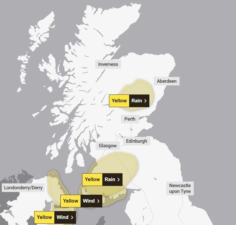
 Yellow warnings for rain and wind issued for parts of Scotland
 - Forecasters have predicted the potential for flooding and travel disruption in the affected areas
- Ferry services cancelled as police urge people ‘not to travel’
Parts of Scotland are braced for a week’s worth of rain within days amid Met Office weather warnings and flood alerts.
A yellow weather warning comes into force at 6am on Friday and remains in place until 6pm. An additional warning for wind comes into effect at 8am covering southwest Scotland.
Areas such as Argyll, East Ayrshire, Stirlingshire, and Perthshire could see as much as 70mm of rain on higher ground, according to STV meteorologist Sean Batty.
The warning for heavy rain covers Angus, Perth and Kinross, Aberdeenshire, Dumfries and Galloway, Scottish Borders, East and South Ayrshire and South Lanarkshire.
 Met Office
Forecasters have predicted the potential for flooding and travel disruption in the affected areas.
The Scottish Environment Protection Agency has issued six flood alerts in Aberdeenshire and Aberdeen City, Ayrshire and Arran, Dumfries and Galloway, Dundee and Angus, Scottish Borders and West Central Scotland.
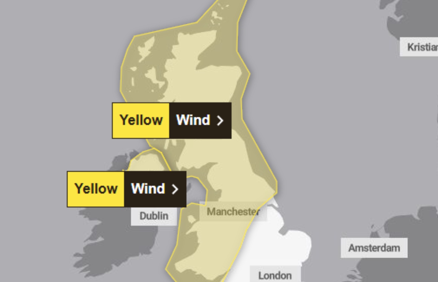
The heavy rain will be followed by strong winds with gusts of up to 70mph on Sunday.
The Met Office confirmed all parts of the country will be hit with strong winds which could bring disruption to travel routes and on roads.
 Met Office
The warning is in force from 6am to 6pm on Sunday for most of the UK.
Southerly to southwesterly winds are expected to increase through Sunday morning, peaking late morning to early afternoon with gusts of 50-60mph.
Police Scotland confirmed that a number of sailings between Cairnryan and Northern Ireland have been cancelled on Friday.
The force said customers booked on affected sailings are advised not to travel to the area due to the impending weather warnings.
“They should instead seek alternative travel options elsewhere. Please check with Stenaline and P&O Ferries as appropriate for updates on your sailing,” a spokesperson for Police Scotland said.
“Freight drivers who must attend the area are advised to follow instructions from port operators and Police Scotland about accessing the Operation Overflow site while the cancellations are in place.”

Insight Sean Batty STV meteorologist
After weeks of colder and relatively settled weather, we’re about to shift into a much more unsettled but milder spell.
Temperatures on Thursday and Friday could climb into the mid-teens in parts of the north, particularly around Moray and the north Highlands.
However, the biggest talking point will be rainfall, especially on Friday and Sunday, which are set to be the wettest days.
On Friday alone, areas such as Argyll, East Ayrshire, Stirlingshire, and Perthshire could see as much as 70mm of rain on higher ground.
Combined with additional rainfall on Thursday and Sunday, totals could exceed 100mm in the wettest parts of the west Highlands and the western end of the Southern Uplands.
To put that into perspective, Perthshire typically sees around 100mm of rain for the entire month of February, meaning some areas could receive three weeks’ worth of rain in just a few days.
Other particularly wet spots will include the higher areas of Renfrewshire and Inverclyde, where around 60mm could fall—Clyde Muirshiel will be especially wet.
Strong winds will also be a feature in the coming days, with the worst conditions again expected on Friday and Sunday.
Wind gusts up to 70mph are possible for a time on Friday across Arran, Kintyre, the Small Isles, and the Outer Hebrides, with similar gusts expected again on Sunday, extending to the Northern Isles.
Looking ahead, this unsettled pattern is likely to continue until March, with further spells of windy and wet weather, interspersed with brief colder, more wintry periods.
At this stage, it looks like March will come in like a lion — let’s hope it goes out like a lamb though.
Follow STV News on WhatsApp
Scan the QR code on your mobile device for all the latest news from around the country