Forecasters are watching for “perhaps the most significant El Niño this century”.
But what is El Niño and how could it affect us here in the UK? ITV News explains.
What does El Niño actually mean?
El Niño was named in the 1600s by Spanish-speaking fishermen off the west coast of South America who noticed unusually warm waters appearing in December.
As this happened around Christmas time – it was named in reference to baby Jesus, or “the little boy”.
The opposite of this weather phenomenon is called La Niña, “the little girl”.
Why are these usually warm waters around South America important?
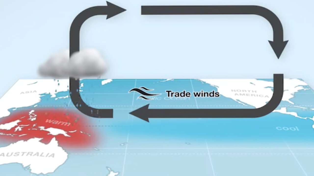
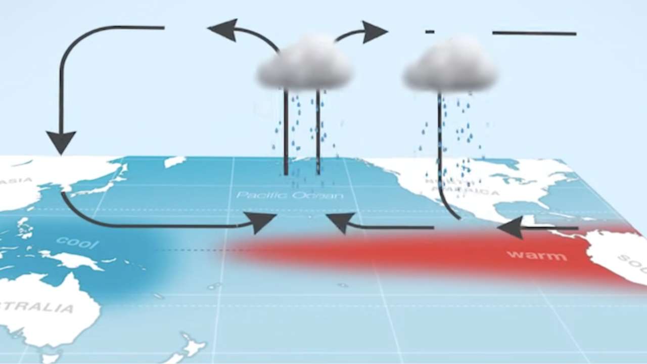
An El Niño event is an interruption in the usual movement of weather in the tropical Pacific between South America and Australia.
In the normal course of things, winds (known as Trade Winds) blow east to west from South America to Australia, sweeping the warm water near the surface of the ocean.
It then pools around the east coast of Australia whilst cooler water close to South America is pulled up from deep in the ocean to replace it.
So, imagine cooler water around the South American side of the Pacific and warmer water close to the Australian side.
Put simply, the warmed air above this warm water close to Australia rises, condenses and gives rain across eastern Australasia.
The cooler, drier air flows back eastwards across the tropical Pacific and falls back towards the ocean over the cooler water.
It acts like a self perpetuating water cycle (officially known as ‘The Walker Circulation’).
At it’s most ramped up, this event is referred to as La Niña where the warm pool of water to the west is larger and warmer than normal and the cooler water to the east is colder and also larger than usual.
However, every few years, those trade winds weaken, which allow those warmer waters to drift back towards the east – a change that is called El Niño.
This pool of warmer water shifting eastwards means that the rising warm air/evaporating/condensing cycle that generated rain towards the western Pacific instead shifts towards South America.
Without this rain, droughts and heatwaves in particular are more likely towards Australasia.
And, because the tropical Pacific is such a key driver of the atmosphere, a change in “normal” weather patterns here impacts weather patterns around the world with heavier rain and flooding to parts of South America for example and, very notably, changes to monsoons and storm tracks around the world.
What’s happening right now?
We’ve been under the influence of La Niña since late 2024, which has slightly taken the edge off global temperatures but now experts are seeing strong signals of a potential El Niño developing later this year – and this one is giving all the signs that it could become a very strong event – with the knock on effect of bigger global weather impacts.
How could this affect the UK weather?
There’s often a lag between El Niño developing, and the impacts to the UK.
If it did develop during summer, which is very possible, we could have a greater chance of higher temperatures at the end of summer.
A more likely outcome is that we would see effects during the winter, as the chances of a colder winter increase.
Could this mean more global heat?
Very possibly. El Niño tends to release heat from the ocean into the atmosphere, giving global temperatures a temporary lift – potentially around 1.5C above pre-industrial levels.
Against the backdrop of climate change, that extra boost can be enough to push the world towards record-breaking warmth.
2024 was, globally, our warmest year on record – and yes, it was influenced by a strong El Niño event from late 2023 into early 2024.
Is climate change affecting this?
That’s an area scientists are still exploring.
There are signs that both El Niño and La Niña events could be becoming more intense, which may lead to more extreme swings between floods, droughts and heat.
What’s already clear is that even “cooler” La Niña years today are warmer than El Niño years a few decades ago.
So, while El Niño is a natural part of Earth’s climate system, it remains an incredibly powerful driver of global weather.
As we move through this year, a strong El Niño is increasingly likely – and while it won’t determine our day-to-day weather, it can quietly load the dice, raising the likelihood of certain – potentially impactful – weather events both here in the UK and across the world.
Follow STV News on WhatsApp
Scan the QR code on your mobile device for all the latest news from around the country