 PA MEDIA
Homes in Scotland could be hit by floods in the coming days.
Around 120mm of water is set to fall over a 36-hour period on Tuesday and Wednesday for areas including Perth, Stirling, and Dumfries and Galloway.
An amber weather warning for rain likely to cause flooding and travel disruption is in place for these regions until midday on Wednesday.
The Met Office has also issued a yellow warning for wind covering Scotland and Northern Ireland, where gusts of up to 50mph are expected on Tuesday.
From Monday to Wednesday, spells of sunshine and rain are expected for most of the nation – a combination likely to bring “plenty of rainbows” according to the Met Office.
STV meteorologist Sean Batty said: “We’ve now entered a significant mild spell after the extreme cold we had the previous week, and with that much milder air comes a lot of rain.
“Over the last week there’s been some flooding issues, exacerbated by snow melt raising some river levels, particularly in the north east where we had over 70cm of snow recorded in parts of Deeside.
“The focus for this next spell of heavy rain will be on southern and central Scotland, as well as Tayside, with as much as 120mm possible in a few spots.
“I expect the highest totals to be along the southern end of the Grampians and the Southern Uplands, with half a month’s worth of rain falling through the course of Tuesday.
“This amount of rain will likely lead to flooding of properties nearby rivers along with the usual flooding of the usual roads and fields during periods of very wet weather.
“Rivers levels will be particularly high in the Tayside area where we’ve already had high levels recently and still some snow thawing on the mountains.
“While more rain will come and go for the rest of the week, there won’t be anything as bad as this. So the main risk of flooding will be Tuesday, but also a risk of more on Wednesday due to a lag of the water coming off hills and mountains into our rivers.”
Met Office spokesperson Oli Claydon said a band of showers concentrated in central areas of England, and covering parts of east Wales and south-east Scotland, will gradually ebb away on Monday, leaving scattered sunny spells in its wake.
But heavier rain will return overnight, which will be largely concentrated in Scotland and north-western areas before moving south-eastwards as it weakens over Tuesday and Wednesday.
Mr Claydon said mid-teen temperatures are expected to continue across the nation, which seem “especially warm” following the recent freezing weather.
“We’re getting milder and wetter air from the west causing warmer weather all round, but we’re a way off hitting a February record,” he said.
“These mild temperatures are set to stick around through the week with peak temperatures of 14C and 15C in south-east England.”
Mr Claydon said the average maximum temperature for February was recorded as 21.2C in 2019.
The warm streak is set to continue through the week and into the weekend, which is expected to be more “settled and sunny” across the board.
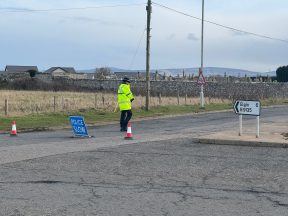
The heavy rainfall forecast on Tuesday and Wednesday comes as flooding caused travel disruption across the UK over the weekend, including in Perth and Kinross where roads near the River Isla were closed.
Areas of England and Wales hit by floods over the weekend where some homes were evacuated can expect lighter rain in the coming days, and some respite from the disruption.
Residents in central and western Scotland have been advised to check Met Office updates.
Follow STV News on WhatsApp
Scan the QR code on your mobile device for all the latest news from around the country